North Bay

Although considered to be in northern Ontario, if you look at it North Bay really isn’t that far north.

“Just north enough to be perfect” according to its slogan, North Bay is the second city of Ontario’s near north (after Sudbury.)

Considering what southern Ontario considers to be ‘north’, maybe “just north enough to be perfect” should be Barrie’s slogan? Kidding…!North Bay, Ontario, Highway 11

Explored by Samuel de Champlain, North Bay wasn’t founded until 1891.  Primarily a railway town, North Bay once harboured massive ambitions of being Canada’s Panama – there were plans for a canal stretching from the Ottawa River through the town to Lake Nipissing, which would have essentially been a massive shortcut for boats en route from Thunder Bay.  This never materialized.  North Bay did however play an important role during the silver rushes in Cobalt as it was the hub of both the CPR and the ONTC line up to northeastern Ontario. Today, North Bay is largely a university, military, and (most importantly) a transportation town.

Highway 11 ontario north bay highway11.ca

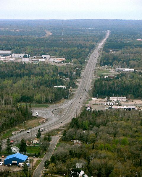
Highway 11 heading out of North Bay (Credit: P199 from Wiki Commons)

I’ve driven through North Bay five times, and stopped in a couple of other times for visits of a few hours.  It has all the amenities a trveller could need – from motels to real hotels, from diners to chain restaurants, from no name doughnut stops to Tim Horton’s.

North Bay is essentially the last place to get a full range of big city shops, services, and franchises before Timmins, or if you plan to stay solely on Highway 11, the last place before Thunder Bay.. I was once told by a facetious friend that North Bay is Cree for “a place on the lake where the gas is cheaper.”  While that’s obviously a joke, the general point about gas prices is true – sometimes as much as 15 cents cheaper than its more northern counterparts.

Lake Nipplesing, North Bay, highway 11

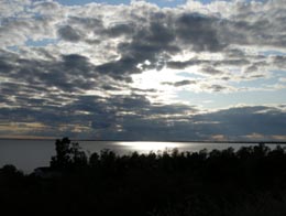
Lake Nippissing under clouds.

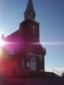
North Bay is home to a really nice restored theatre – the Capitol Centre – that hosts plays and concerts. (I got dragged to an Anne of Green Gables play while we were there…and I can’t believe I’m admitting this but it was actually kind of good.  The island, the island, we’re from Prince Edward Island…we’re island, we’re island throughandthrough…)  Although the theatre doesn’t immediately catch the eye (it’s on Main St, or Oak St, I can’t remember) the inside is really quite nice. There truly isn’t a bad seat in the house.

North Bay was home to Mike Harris, a two-term Ontario Premier during the late 1990s in Ontario whose name pretty much became a curse-word if you were a public school student at the time.  He’s famous for the coining the phrase “common sense revolution.” Oh, and the Dionne Quintuplets were born in nearby Corbeil Callander.  Their exploitation brought a fair amount of money to North Bay during the depression.  Kids in the Hall comedian Scott Thompson was born in North Bay (I think he grew up in Scarborough though), as is weatherperson Susan Hay and a pretty not so great band called High Holy Days.

Plan in North Bay, highway 11, Ontario

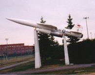
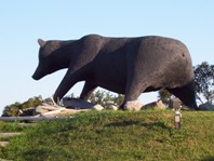
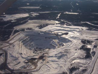
North Bay’s “some big weird thing” is a bit more refined than some other northern Ontario towns

North Bay is also famous for being the hometown of Roy Thomson, the founder of the Thomson media empire and the namesake of Toronto’s Roy Thomson Hall, one of Canada’s premiere music venues. Roy Thomson started out selling radios door-to-door in North Bay. This interest in radio led to him taking over the local radio station, taking over or establishing more radio stations, then expeanding into newspapers – eventually making him one of Canada’s most successful businessmen.

North Bay cruise tour highway 11

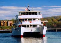
I once chuckled at an acquaintance who recounted their engagement story, which occurred under a Tuscan sunset.  I shouldn’t have laughed – I almost proposed on a boat tour of Lake Nipissing

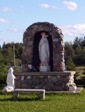
Tourist activities include the Commanda boat tours on Lake Nipissing, and the beach, walkways, and mini train ride at the city’s waterfront.  There are plays (Nipissing Stage Company) and festivals (The Heritage Festival every August Civic holiday.)  The Dream Catcher Express used to run a day-trip train to Temagami to view the leaves in the fall – but that’s been cancelled since the government shut down the ONTC. There is also the original Dionne House, where to Dionne quints were born (the house pictured second from top on the left), which has been moved into town and turned into a little museum. The museum is open from Spring to late October, and entrance is about 3$ each, and is worth a visit if you’re in town.

Dionne House Museum, Ontario, Highway 11

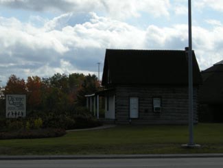
I never cease to amaze myself with how crap my photos can get. This is the Dionne Quints Museum house.

What else can I say about North Bay?  You know, this site is kinda focused on the more northern towns, like Timmins, so I guess I’m not always putting as much content up about places like Barrie or North Bay, etc. I guess since North Bay is a bit bigger than the average town on this site, there is less I have to tell you. North Bay is pretty nice, it seems like a good place to live and a great place to grow up – but this site is a bit more about the smaller, more remote towns to its north. (I got flack from a poster on the Huntsville page for this site’s north-centric focus, I’m waiting for same flack to be posted on behalf of North Bay too…)

Fun in North Bay, Highway 11

For a while I had no photos of North Bay, and this was the first that came up in google

Ramore

Ramore is a quiet community about one minute east of Highway 11 on road 572.  It is 15 kilometres south of Matheson and is made up of three streets (Fergus, Timmins, and one other street I forgot to write down.) Ramore, surprisingly, was the home of two air bases, part of the Mid-Canada and Pinetree Lines.

Ramore, Ontario church off Highway 11

Church at sunset in Ramore

Predominantly francophone, Ramore (and its cousin Holtyre) reminds me a bit of Val Gagné – small, quiet, clean, about 40 houses (probably more) – except with more agriculture.  The area is surrounded by farms – some fallow, others still producing – which gives the area a relaxed, summer feel and some pretty fields and old barns. (And for some reason, there’s a house with a Canada flag and a Barbados flag.)

Ramore was a railway town, forestry centre, and agricultural area, but in 1950, the Americans came to town and built a Pinetree Line radar station – not by accident. The mountain the radar site was located is a high-point in the region. The mountain next to it on the west side of the highway is called Kempis Mountain. Both are prehistoric volcanoes that are long dead. Near the Radar Base, is an airstrip – not widely known. Most still think that the military built it, but that is not so. The airfield was built in the 1930’s as a make-work program during the Great Depression. It was part of some sort of larger aerial mapping program. The strip was built, but WWII came along. Not sure how much use it really got, until the Air Base was built, nearby.

Ramore church shrine, Highway 11 Ontario

Shrine at the church in Ramore

The Air Base played a large role in the area, both socially and economically, from Kirkland Lake to Matheson. In 1962, the Americans turned the base over to the Canadians. It was part of a deal that resulted due to the cancellation of the famed Avro Arrow Program. Canada would “lease” 66 F-101 Voodoos and take over 12 Pinetree Radar Bases – this included Ramore. Supposedly due to budget cuts and changing technology, the Base was closed in 1974. A similar base at Lowther was dismantled in 1984.
Interestingly, up until the mid-60’s, Kempus Mountain had a small “air base detachment” separate from the Ramore base. This is because, Kempus Mountain was part of the Mid-Canada radar system. Kempus was a relay station for the Mid-Canada line (which was a different line of radar stations than the Pinetree line), which operated generally around the 60th parallel. This is one of the few places in Canada where the Mid-Canada Line and Pinetree Lines met. As the site of two former air bases, one can say, that Ramore had a very strong connection to the Cold War. Today, one of the bases lay abandoned and some people still explore it, however it is not recommended due to the physical hazards and the potential of running into harmful contaminants.  (Click here for photos of a visit to former base location in 2002.)

South of Ramore on Highway 11 is the Ramore Flea Market.  Albeit small, this is a real flea market, not like the North Cobalt Flea Market.  I haven’t had a chance to look around, but it’s worth a stop since it’s right on Highway 11.
Raymore also hosts a Country and Western Festival every September, complete with concerts, demonstrations, and competitions.  I don’t know if there is a midway.

Ramore Flea Market, Ontario Highway 11

Drove past at least 20 times. Always wished I had stopped by.

Ramore has a church, a baseball diamond, a small library, a caisse, and Bouchard’s Grocery and LCBO outlet, which is more like a convenience store with food.  Just south of the town is Rolly’s Motel and Home Cooked Meals, which has rooms and food but no gas.  There are blueberry stands both north and south of Ramore, as well as a family that sells vegetables from a stall.

Thanks to Dwight for the info and for pointing me towards the photos of the radar base.

For an archive of the 40 comments that were posted to Highway11.ca’s profile of Ramore between 2008 and 2012, please click here.

Kapuskasing

Kapuskaing, Cold Weather Test Centre, GM, Highway 11 Ontario

Nothing says “welcome, why don’t you stay a while?” like seeing the Cold Weather test centre from your car window

Which Highway 11 town has 9000 people, more than 50 shops and services and was the hometown of the director of movies like Terminator, Aliens, True Lies, Titanic and Avatar?

Yep, Kapuskasing is kindofabigdeal in Highway 11 terms.

Kap has some neat sites.  The old Ontario Northland train station has been recently fixed up and has a little area for art exhibitions from the area.  There’s an old locomotive adjacent to the station that houses train memorabilia and neat facts about the CNR’s history.

Highway 11 Ontario, Kapuskasing, bear

Kap’s entry into the “some big weird thing” – a bear

Originally named Macpherson, the ‘model town of the North’ was built around the pulp mill that originally supplied paper to the New York Times.  When they built the mill, they decided to build a company town, and since it was a company town they planned it as the ‘model town of the north’ complete with planned parks (quite nice), its own power supply (which used to serve the town and mill exclusively), and an English-style traffic circle, which residents and visitors alike find confusing to this day.

MOdel Town of the North, Kapuskasing's roundabout

You know roundabouts are confusing when they are a pain even in a town this small

With about 9000 people, Kapuskasing is the largest town on Highway 11 between Kirkland Lake and Thunder Bay.  It’s even has its own spot on the North American professional lumberjackery circuit.  Every July the Kapuskasing Lumberjack Festival is broadcast live on television across Canada, and maybe even into the States. (Heck, Canada doesn’t even have a soccer league, but it has a lumberjack circuit?  And is sustainable with stops in towns like Kap?  Who would have guessed it…)

POWs

Kapuskasing POW memorial, Highway 11I was surprised to find, by accident, two little memorials just west of Kap.  There’s one for Ukrainian-Canadian detainees tha

t were interred near Kap during the First World War (the photo of the guy with the hat.)  Further in off the highway there’s one for German/Austrian/Turkish Prisoners Of War (the photo with the little crosses) that died while being imprisoned.

I found out from some locals at the site that during the First World War Kap was the site of a POW camp.  It was decided that

Kapuskasing POW camp memorial, Highway 11 Ontario

Kapuskasing POW camp memorial

Kapuskasing was perfect because at the time the only way in and out of town, at that time, was by train.  In other words, everyone detained there was stuck – there was no way to escape and nowhere to go if you did.  They used their labour to clear land for Kapuskasing’s experimental farm, which is right beside the 24 graves of the POWs.

In addition, Paul emailed me to tell me about Kapuskasing’s former life as a station on the ONR rail line. Every time a train derailed, the local foreman of the track maintenance crew at Kapuskasing was required to file a report with the head office of ONR in Toronto. His reports were apparently quite lengthy and detailed. After receiving many of these “eloquent” and “descriptive” reports, about train derailments the foreman (named Flanigan) was advised by the head office people to write reports that weren’t so lengthy. So, after the next derailment, the following telegram was received in the head office, as follows:

Re: ONR train derailment at Kapuskasing:
”Off again – on again – gone again” (Signed) FLANIGAN.

Farm near Kapuskasing. Highway 11

Still farm country this far north

Kapuskasing Today

Like all the francophone towns (it’s about 30/70 anglo/franco) of the north, Kapuskasing is really quite nice.  Although a James Bay tourism brochure bogusly claims that Kap is a town of “street dances” (who wrote that thing?), there is a fair amount to do for a city of its size.

Kapuskasing train station

Kap’s train station is pretty magnifique, with a museum and gallery

There is a farmer’s market in the summer.  If you can make it past the downtown traffic circle in the direction of your desire, you’ll find a really nice lakefront park and some good walking paths.

Kap has a bunch of services that are too long to go into detail here.  What’s important is that there is a Tim Horton’s.  There’s a McDonald’s too.  There are some honest-to-goodness northern Ontario Chinese food restaurants.  There is a Walmart but no Giant Tiger.  Apparently Kapuskasing also has the most productive Casey’s restaurant in all of Ontario.  Take that, Front and University (the downtown Toronto location.)

Pub Max, right on Highway 11, also has good food, especially the chicken salad sandwich.  There are two touristy stores on Highway 11 in Kap, namely Marbleworks and the Moonbeam Country Store.

Agrium Mine, Kapuskasing

Aerial view of a mine, near Kapuskasing

Lowther

Lowther is dead.  Long live Lowther.

I’ve been told by a Mattice resident that Lowther is on the map since it used to be the home of a NORAD base until the mid-1980s. Dwight confirmed this.
Much like the radar base around Ramore, the Lowther baseclosed in 1987. However, unlike Ramore, when they closed the place absolutely everything was removed within a couple years. The first photo below shows the Lowther base from Highway 11, in 1984. The second is an aerial shot of the base, with Highway 11 running diagonally in the background.

Today, Lowther is just an empty area where the radar base and all buildings existed. While Lowther is on the map, it no longer exists.

Thanks to Dwight for the info, and for pointing me to the photos linked below, care of Marg and Ren l’Ecuyer’s Pinetree Line website (www.pinetreeline.org)
Photo Links: Pinetree Line – View of Lowther Base from Highway 11, 1984, Pinetree Line – Aerial View of Lowther Base from Highway 11, Pinetree Line – Dismantling of Lowther Base, 1989, Pinetree Line – View of Lowther Base from Highway 11, 1998

Nakina / Aroland

North of Geraldton you’ll find two towns on opposite ends of Highway 548 – Nakina, and Aroland.

Nakina is village of approximately 500 people on Highway 584. The village is situated approximately 60 kilometres north of Geraldton – making Nakina one of Ontario’s more remote towns on the road network.

Nakina highway ending, Ontario highway11.ca

At the end of one of the most northerly stretches of road in Ontario are Nakina and Aroland

With 500 people today, Nakina is essentially the remnants of an old railway town. The town was founded in 1913 due to the junction of the railway – after Nakina the rail lines branch southwards towards Toronto or east towards Quebec. This made Nakina an ideal spot for a railway centre. In its heyday, Nakina has a fully functioning roundhouse, with fuel, servicing, and train-turning facilities.

The 1940s saw Nakina get a radar base. Built in World War Two, the base was designed to protect the important locks between Lakes Huron and Superior at Sault Ste. Marie. Like many of Canada’s old radar bases, it was operated by the United States, but dismantled soon after the Second World War.

Nakina, Ontairo way up north a fair bit off Highway 11

Nakina, harkening back to the old days of northern Ontario railway towns (Photo: User P199 at Wiki Commons.)

Nakina hit a boom in the 1970s when, in addition to its railway functions, the town was home to a large paper mill. This boosted the population to nearly double what it is today. Currently, however, minerals exploration and tourism are the largest industries today. Nakina is a starting point for many northern fly-in lodges. You can fly to lakes such as Makokibatan, part of the Albany River system. Fish for walleye, northern pike as well as brook trout.With both the pulp and railway industries definitely on the wane, it may be hard for Nakina to stem out-migration and beat the odds of being such a remote, northern town.

Train station in Nakina, Ontario Highway 11 Homepage

Nakina’s train station

Nakina advertizes along Highway 11 with its mascot, the “Nakina Mosquita”… I wish I had taken a photo of one of those signs. Thanks to Keith for sending in the photos of the rail station and of the end of Highway 584.

Aroland is an Oji-Cree First Nations town about 20 kilometres northwest of Nakina off Highway 584 on Highway 643. Approximately 300 people live in the community.

The surrounding area was a traditional camping ground in the late 18th and early 19th centuries due to good hunting, fishing and trapping. The Hudson Bay Company set up a trading post at nearby Kawpaskagami Lake in the early 1900s. The railway expanded to the area in 1911. According to the Chiefs of Ontario website, the Arrow Land and Logging Company, which operated in the area from 1933 to 1941, employed many Band members and contributed to the establishment of a permanent community.

The community is made up of members from many First Nations across the north, including former members from Long Lake, Fort Hope, Marten Falls, and Fort William Bands. The Aroland settlement is within the boundaries of the Robinson-Superior Treaty of 1850 and the James Bay Treaty of 1905 (known across the north as Treaty 9.)