Porquis Junction

The hamlet of Porquis Junction is about 10 minutes from Iroquois Falls. Porquis Junction used to be a small agricultural centre, with its own agricultural hall and even a John Deere dealership (Jensen’s Sales and Service) which serviced farms from Iroquois Falls to Matheson up until the early 1990s.

Porquis Junction agricultural hall

Reminder of agricultural days of yore in northern Ontario

As far as I can tell, it is not pronounced Por-kee but Pork-wiss, which to me sounds like a brand of tinned ham.  The town should nominate someone as the official ‘Marquis of Porquis’ every year at the end of the Blues Fest or Ag Festival.  Why?  Because it just sounds cool.

Porquis must be the festival capital of the north as it hosts a number of different celebrations despite its relatively small size.  Known across the north, the Porquis Blues Festival is held on a small covered stage behind the community centre every July.   The town also hosts an Agricultural Fall Fair in August.  In 1986, the town made the news when the Porquis Fun Days festival attracted world-famous wrestler André the Giant, who then proceeded to eat the hamlet out of house and home.Porquis Jucntion blues festivalPorquis is about 10 minutes off Highway 11, on the way to Iroquois Falls.  This was the second time, after Opasatika, that I had been chased by a dog while taking pictures – I guess he was bored. Or just very protective of the Porquis Junction Agricultural Hall.

POrquis Junction Cunigold Mines truck highway11.ca

Old Cunigold Mines Truck, sent in by Linus

Iroquois Falls

Iroquois Falls isn’t right on Highway 11 – it’s about 15 kilometres away at the end of road 67.  Founded more than 90 years ago, Iroquois Falls is home to a big pulp/paper mill and three electricity dams — all of which together used to be the world’s largest pulp and paper operation.

Iroquois Falls, OntarioIroquois Falls (pronounced locally as Urr-roquois, not Ear-roquois) is about half anglophone and half francophone.  The town is split in two by the railroad, and crisscrossed by the tracks at an innumerable amount of locations.  (I wonder if Iroquois Falls has the highest number of railroad crossings per capita in Ontario.)

Interestingly, the west half of the town seems to have English street names, while the east side’s streets are in French.  There is even rue Synagogue – a testimonial to the Jewish population that once settled in northeastern Ontario.  And while we’re on street names, there’s also Oil Tank Road, which is just begging to be the name of a country album.

Iroquois Falls was comprised of at least three communities – Iroquois Fall, Ansonville and Montrock. Amalgamation has put them all together under one municipal roof.

The Shay in Iroquois Falls

The Shay, Iroquois Falls’s old locomotive

The Abitibi Arena in Iroquois Falls was built entirely by community labour in 1955. Actually, at the time it was billed as the largest community labour project in North America. A large contributor to the project was personnel employed by the paper mill. If a part or piece of equipment was needed somewhere during the construction apparently it was readily made by a millwright over in the paper mill.

Iroquois Falls woodpile at the mill, Highway 11

Sometimes this travel blog feels like a tour of northern Ontario woodpiles (Credit: User P199 at Wiki Commons.)

Known as “The Garden Town of the North”, Iroquois Falls is home to The Shay, an old restored locomotive that used to work the Abitibi line.  The town is also home to the Abitibi Eskimos, a junior hockey team that draws record numbers in the Northern Ontario Junior Hockey League.  I’ve heard that people come from as far as Kirkland Lake to watch the Eskies.  Iroquois Falls celebrates Paperfest in August and the Moby Pike fishing Derby in July.  There is also a Pioneer Museum in town chronicling the rise of the forestry industry and settlement of the town.Iroquois Falls Eskis logo

Iroquois Falls used to be the home of a large, wooden hotel that was served by an fantastic dining room. Unfortunately, it is no more, either being torn down or burned down at some point before I had a chance to have a meal. Randy’s Rec Room is a pub serving surprisingly good food and the service is top notch.  For food there is also the Main Street Café, the Bus Stop Chip Stand, DJ’s pizza, a diner, and a Tim Horton’s.  There’s a motel when you’re coming into town, but I don’t think the adjoining steakhouse has been in operation for years.  There are some bank branches and a caisse.  Esso (west of the tracks) and PetroCanada (east of the tracks) are in town as well. And the Silver Grill is a Chinese place serving 100 percent northern Ontario Chinese food.

Iroquois Falls is a pretty nice town.  There are nice old houses, a few parks, and a marina at Twin Falls that provides access to the massive Lake Abitibi.

Thanks to Paul for the info on Iroquois Falls.

Tunis / Nellie Lake

One my drives up Highway 11 after Iroquois Falls, I didn’t see much in Tunis, at least not much that was directly on the highway itself.

Dutch from Kitigan emailed me to tell me that Tunis, was the home of a huge church that was used as a vacation retreat for Catholic priests and nuns. About 25 years ago, the church sold everything, and left. New owners tried to run a motel out of the complex, but it soon went under, and burnt down five years later.

About 15 years ago, a large power plant was built not far south of Tunis, financed by the Ontario Teachers Retirement fund.

As far as I could tell, Nellie Lake consists of a gas station, a few houses, and an an abandoned motel/gas bar complex along Highway 11.

However, according to some helpful emails from Sarah, I seem to have missed all the fun. Nellie Lake requires that you leave Highway 11 to truly find it.

Nellie Lake (the town) is largely a small cottage hamlet off the highway. Worth checking out is the lake itself, which has beach facilities and apparently picturesque and transquil surroundings. Cameron’s Beach and Trailer Park borders Big Nellie Lake and offers camping and trailer services alongside the water.

Cochrane

Chimo the Polar Bear in Cochrane, ON

Travel blog lesson #31 – always take a second, empty, non-person photo.  Or else you may end up with a blog full of photos of previous girlfriends.

Most towns would make a big deal of the fact that a former hockey player and doughnut baron hailed from their community.

Instead, Cochrane advertises Nanook, Aurora, and Nakita as its three most famous citizens.

Yep, we’re talking about animals.

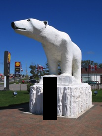
If you have a fear of polar bears, steer well clear of Cochrane. I’m just teasing – they’re well contained. Cochrane has adopted the polar bear as their town symbol, even though true polar bear habitat is more than 300 kilometres away.  There are even fake igloos in town.

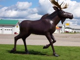
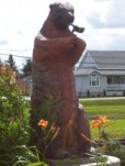
Chimo, the town mascot, is honoured with a big polar bear statue just as you enter town.  There’s also the Polar Bear Conservatory, where Nanook, Aurora, and Nakita spend their time.  There you can watch feedings, see interpretive displays, and “swim with the polar bears.” Ok, so if you’re more than 4 feet tall it is more of a wade than a swim but don’t let my teasing dissuade you – the Polar Bear Conservatory is interesting. Kids love the wading with the polar bears part. There’s also an adjacent ‘old style’ village with gas pumps, farm implements, and a collection of really awesome vintage skidoos.

Polar bear conservancy in Cochrane, Ontario

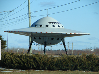
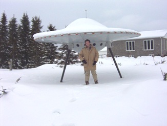
This was pretty cool, to be honest

Old Tyme Village ski-doo collection, Cochrane, Ontario

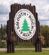
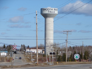
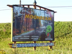
Definitely the most northern Ontario museum in northern Ontario

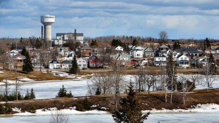
Cochrane is a very pretty little community of 4500 (slightly more anglophone than francophone) on Highway 11.  No matter what language you’re in, Cochrane is pronounced like cock-ran.  This might seem pretty intuitive but once in a gas station with a bunch of tourists from Belgium who kept asking how to get to a place that sounded like Cosh-rahnne and no-one, not the anglos nor the francos knew what the heck they were talking about.  I only figured it out about a year later.  Hopefully it didn’t take them that long.

Old locomotive on display in Cochrane, Ontario

(Credit: Patrick)

It has a growing tourist industry built on the Polar Bear Express, which runs north to Moosonee twice a day in the summer.  Or at least it did, until the government stopped supporting the railway and now no-one knows what’s happening to the ONR.

Fishing and ATV expeditions often start here.  Greenwater Provincial Park is about an hour west of the town, providing fishing, swimming, and hiking around a series of kettle lakes.  Greenwater is pretty, and quiet. Also notable is the Tim Horton arena, home to the Tim Horton museum, that I didn’t have a chance to visit.

One of the coolest things about Cochrane, in my books at least, is Lake Commando. One –  that’s a sweet name.  Lake Commando. Sure, it’s more like a pond, but the words ‘Lake Commando’ just sounds so cool.  That’s awesome.  That’s even cooler than Geraldton’s Hardrock Drive, or Iroquois Falls’ Oil Tank Road. Two – it’s pretty.  It has parkland around it, a walking trail, and a quaint little bridge.  There’s also a bed and breakfast bordering the lake.

Cochrane, Ontario train station leads to James Bay

Cochrane train station.  (I do not know how to effectively use my camera in any lighting – dark or bright.)

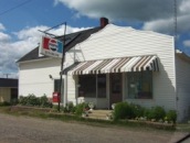
As for amenities, since Cochrane has about 4500 people it’s fairly well served.  If you’re looking to bring out your fancy-pants you may be out of luck, but otherwise there’s everything you need.  Cochrane has a Tim Horton’s (which pays homage to the town’s most famous son with plaques on the walls, memorabilia all around), a KFC, and some other diner-style restaurants.  There’s also a rib/wing place and the Station Inn if you want a real sit-down meal, and, of course, a place serving Authentic Northern Ontario Chinese Food.

Cochrane, Ontario on Highway 11

Can you milk a polar bear? Well, Cochrane sure does. (Photo credit: Patrick)

There’s a small farmer’s market at the north end of town every Saturday, and a country store you’ll see across from the polar bear statue that sells cottagy-type stuff that you see in Muksoka.  Also, Cochrane has the last Giant Tiger on Highway 11 after Kirkland Lake.

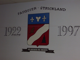
Cochrane is also notable for receiving Ontario’s first ever permit to serve liquor on a Sunday, for a winter carnival held in the mid 1960s. Despite the devastating fires of 1910, 1911, 1916, and Cochrane still exists to this day.

Thanks to Paul for some of the Cochrane.

Lake Commando, Cochrane, Ontario

Lake Commando.  Still looking for Rambo River. (Come to think of it, there was a Rambo Creek near to where I grew up…800 km away)

Cochrane, Ontario off highway 11 highway11.ca

(Credit: User P199 at Wiki Commons.)

Cochrane, Ontario street

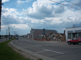
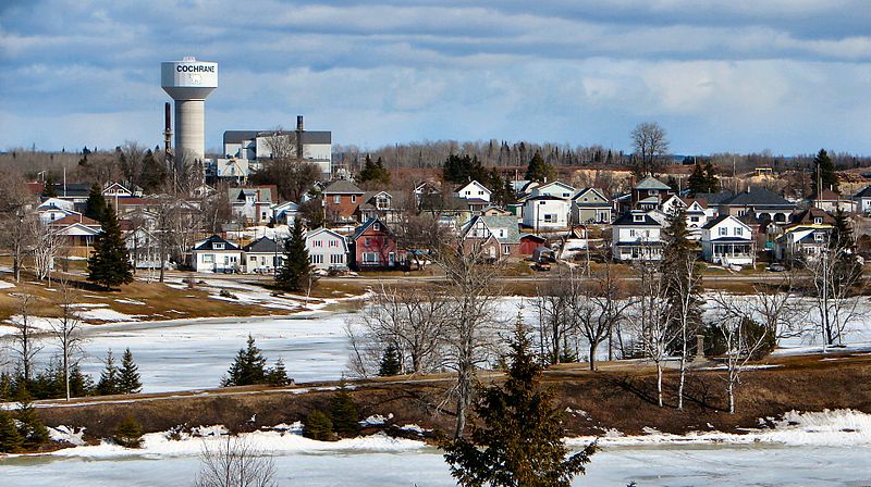
Streetscape in Cochrane

Cochrane, Ontario municipal building highway 11

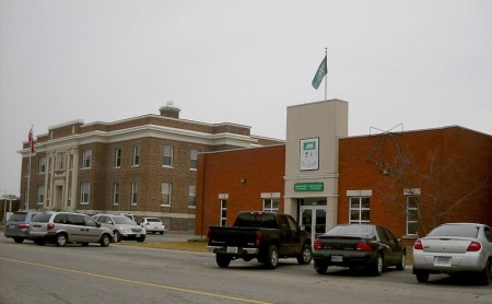
A nicer Cochrane streetscape. (Credit: User P199 at Wiki Commons.)
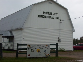
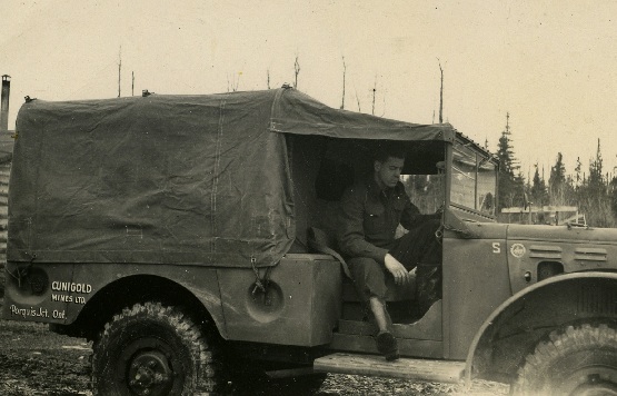
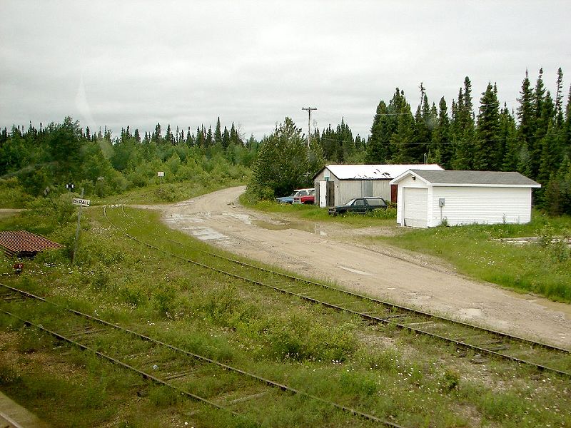
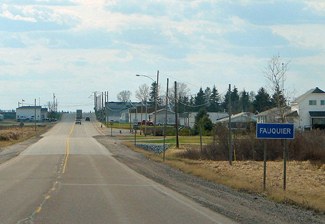
Driftwood

Driftwood is situated 80 kilometres north of Timmins city limits at the corner of Highway 11 and road 655.  There are two homes in Driftwood.  One is for sale.

Otherwise there’s a big truckstop, which is a good place to get gas before Smooth Rock Falls.  The truckstop also has showers and a restaurant that serves a decent breakfast. I used to stop there sometimes on my way from Timmins to Smooth Rock Falls.  One of the servers was this pretty girl about my age with a nice ponytail and I always used to try to sit in her section.  I’m sure I wasn’t the only one.Truckstop in Driftwood, Ontario on Highway 11

Across from the truckstop there is a little alcove where the OPP hides to catch speeders, so beware if you’re continuing along Highway 11.

Smooth Rock Falls

Smooth Rock Falls on Highway 11 in OntarioWhen you come into Smooth Rock from the east, don’t be fooled, what you’re seeing is not a one-story IKEA.  It’s the local hospital.

One tourist guide I picked up said that Smooth Rock was the “perfect stop over and supply center.”  Man, those guys really know how to write a tourist brochure.  Talk about underselling…Smooth Rock deserves more than that!

Jeff Buttle, the pride of Smooth Rock Falls, on Highway 11

Jeffrey Buttle, Canadian and World Champion figure skater is from Smooth Rock

Nestled along the picturesque Mattagami River, Smooth Rock is more than just a town that sounds like a radio station.  It was home to Jeffrey Buttle, a recently retired Olympic silver medalist and world champion figure skater; Louise Pitre, a singer who has appeared on Broadway; and JP Parise, a former NHLer who played in the ’72 Summit Series, has coached at the famous Minnesota Shattuck-St Mary’s hockey program, and who is also the father of New Jersey Devils’ forward Zach Parise.  Those are three people that should have their own “Welcome to Smooth Rock, the home of…” signs on the way into town. I’ll pledge 50$ toward that.

Smooth Rock is a largely francophone community of 1800 centered on the pulp and paper mill.  The problem is that “the North’s biggest little town” (their motto, I think) is about to get smaller as the mill shut down indefinitely in July 2006.  Smooth Rock is facing an uncertain future after the loss of their major employer. Which is really sad, since it’s a cute town and probably a great place to grow up and to retire. I’ve heard that the town and its residents are trying to start up a community-based venture to restart the now shuttered mill, but I don’t know if they’ve been successful.

The mill, now shutdown, at Smooth Rock Falls

The mill, now shut since 2006

Smooth Rock doesn’t have a tonne of touristy-type stuff.  There’s the Forget Me Not BnB west of the river.  There’s also a nine-hole golf course, a nice park on the east side of the river, and there are some fishing opportunities as well. Smooth Rock is good place to stop on the way to Kapuskasing and a place to get gas if you’re heading up to Fraserdale.

Smooth Rock Falls's highway 11 moose

Moose sculpture #234 on Highway 11

Northway Restaurant claims they have the “best poutine in the north”, although I’m sure that Poutineland in Timmins gives them a run for their money.  Audrey’s has good breakfast in a spartan setting.  There’s also Coco’s Chip Stand off the highway.  Rue Sixth is the main business section for Smooth Rock.  There’s a full-blown LCBO, an Esso, and a Tim-Br Mart.  The Moose Motel provides accommodations and SRF’s entry into the “some big weird thing” motif that is all the rage on Highway 11: a statue of a moose.  There is no Tim Horton’s or chain stores as far as I have seen.  I don’t know if there is a Chinese restaurant, but it’s northern Ontario so there must be one somewhere.Also, don’t be fooled.  There are signs advertising the “SRF Centre” on Highway 11 in both directions.  It’s not a mall – the “SRF Centre” is a truckstop with some slightly self-aggrandizing tendencies.

On an anecdotal bent, the town of Smooth Rock Falls used to plow each resident’s driveway in the winter.  I don’t know why that service ended.

Fraserdale

Fraserdale, Ontario, highway 11 siteFraserdale began life as the railway stop three miles from the Abitibi Canyon Colony.  It is not on Highway 11, instead being about an hour’s drive north on Highway 634.

The colony, approximately 5 kilometres from present-day Fraserdale, was constructed by Ontario Hydro to house staff for nearby hydroelectric dams. At its height, the Abitibi Canyon Colony was home to 300 people. Major indoor facilities included a three-sheet curling rink, hockey rink, swimming pool, four-lane bowling alley, billiard room, library, gymnasium, and a theatre. The extent of these facilities were needed to help entertain families in such an isolated location.

Abitibi Dam near Fraserdale

Abitibi Dam near Fraserdale (Photo credit: Patrick, including the next photo.)

However, the Abitibi Canyon Colony fell victim to isolation and economics. Children has to leave the colony for high school or complete final years by correspondence, often boarding with families in Timmins and Kapuskasing. The Abitibi Canyon Colony was the most extensive community ever built by Ontario Hydro, at its height housing up to 1500 residents. Until 1966, the community was only accessible by rail, and even then the train only ran three times per week. By the 1980s, the site cost well over 1 000 000$ per year to maintain. The Abitibi Canyon Colony was eventually phased out in 1980 over a two year period. Check out the Abitibi Canyon Reunion site for some old photos and memories.  The colony’s history is available here.Rail equipment in FraserdaleAccording to info from Don, Fraserdale wasn’t much of a town while the Abitibi Canyon Colony was up and running. Today Fraserdale is a small hydro community, and acts as starting points for bush journeys and wilderness trips, most frequently for canoeists who are traveling up the large rivers to Moosonee or Moose Factory.

Highway 634 began construction in 1966. Completed and paved in 1971, the road links Fraserdale to Smooth Rock Falls and Highway 11, approximately 75 kilometres to the south. Like many northern towns, the community was named for a railway engineer, Alan Fraser.

Fraserdale siding, ontario highway11.ca

Fraserdale siding solitude. (Photo credit: User P199 at Wiki Commons.)

Jamie was up that way a few years ago and reported that the Polar Bear Express will pick up passengers at Fraserdale Station according to a sign at the start of 634 in Smooth Rock Falls. Island Falls GS is a dead end but a good stop where you may be able to see helicopters.  The highway is paved right to Abitibi Canyon GS, and is in great shape.

Recently, author Joseph Boyden wrote a short (fictional) story about the building of a dam in the Abitibi River canyon in his collected of short stories set in the north titled Born With A Tooth.

I didn’t head up the road to Fraserdale during any of my journeys and couldn’t find much on the net. Thanks to Patrick and to Jamie for the photos.

Can you add to this page? Please email me at info (at) highway11 (dot) ca

Fraserdale, hydro generating station, highway 11

View from Island Falls hydro station (Photo credit:  Jamie, including next two photos)

Fraserdale Ontario rapids otter

Fraserdale Ontario 50th parallel highway 11

At the 50th parallel

Gregoire Mills / Strickland

Gregoire Mills, Ontario, on Highway 11Like many other former towns, the mills have left Gregoire. Gregoire Mills consists of seven or eight houses spread out along Highway 11 between Fauquier and Strickland and that’s about all I could find.

Strickland was a stop on the railroad.  It’s actually not on any of the maps that I have, it’s listed as a rail stop but there is a sign on the highway for it so I included it in the Highway 11 website.

Fauquier/Strickland, on Highway 11

Mural on the local gym

Technically part of Fauquier, there’s not a lot in Strickland.  There’s a church, about 15 houses facing Highway 11, and Chez Belanger, the local convenience store.

Local dépanneur in Strickland, on Highway 11

Local dépanneur on Highway 11 in Strickland

Fauquier

Fauquier, on Highway 11 in OntarioFauquier is a quiet, clean, and quaint hamlet of about 600 on the Groundhog River, which is crossed by both a rail and road bridge.

Much bigger than its cousins Strickland or Harty, Fauquier (roughly pronounced Folk-yay) once supported a mill.  Today the community has a few businesses, but I’m told that most residents commute to Kapuskasing.
Fauquier bridges

There’s a statue of a particuarly conniving-looking groundhog just off the highway, as well as a nice gazebo, soldier’s memorial, and a little parkette.  There’s another park just south of the highway, which borders the river and has a little boat launch.

Fauquier's creepy giant smoking groundhog on Highway 11

In northern Ontario, even the groundhogs are smokers

Just east of town, there’s a house with a rather eccentric yard, sporting the Olympic rings (?), some wooden sculptures (??), and a family of inukshuks (???). I didn’t get to take a photo, as the truck behind me was following too closely to safely stop and admire the uniqueness.

Like all the francophone communities on northeastern Highway 11, it is extremely well kept with a church, a dépanneur (convenience store), an LCBO outlet, and a small food store.  There is no gas station, however.

The Den, right on Highway 11, is a good place to stop for breakfast.  I’ve been there a number of times and it’s pretty decent.

Thanks to Patrick for most of the photos.

Fauquier, Ontario on Highway 11

Fauquier sunrise over the tracks

Moonbeam

Ah, Moonbeam.  It’s so cute.  And so goofy.  That’s why it’s so neat.  I like Moonbeam.

Moonbeam, Ontario welcome alien sign on Highway 11

I want to say that the alien’s name is Youpi, but I think that’s the name of the Montréal Expos’s mascot

Moonbeam is a small francophone town of about 1000 (which is big compared to places like Mattice, let alone Harty!)  It is so clean, so well kept, and, well, so spunky.

From what I’ve been told, the town got its name from railway workers who insisted that a beam of light from the moon hit the tracks one night.  And thus Moonbeam was named.  And with the help of hippies and a few dedicated locals, the name stuck.Moonbeam, Ontario's flying saucer on highway 11Moonbeam loves its space theme.  The flying saucer is one of Highway 11’s most famous monuments and is known throughout Ontario.  There is the Blue Moon Motel and Chip Stand (motel + chip truck = awesome combo) which features space stuff on its signs.  Moonbeam has its own mascot which is a little green alien whose name I can’t remember.  He’s on all their signs which are all over Highway 11’s eastern portion. I think I even have him on a shirt pin.

Alien ship stuck in Moonbeam, Ontario because of the cold

It was so cold I had to wear my gorilla gloves. I can’t believe we posed outside without a hat

But it’s not all rockets and asteroids with Moonbeam.  They have a vision and they’re realizing it.  There’s the Centre Culturel and the Leonard Art Gallery.  The town has some of the best hiking, cycling, and walking trails in northeastern Ontario.  Moonbeam has its own snowmobile club with trails that are groomed in the winter (it’s the first place I’ve ever seen a snowmobile trail groomer.)  Just north of town there is Remi Lake and René Brunelle Provincial Park, which I’m told has a waterslide.  There is also fishing, swimming, and canoeing/kayaking.

Moonbeam’s most famous son would be sculptor Maurice Gaudreault.  Gaudreault is well-known within Canadian ceramic circles for his work depicting life in northern Ontario through clay.

Gaudreault sculptureMoonbeam's famous Gaudreault

Gaudreault sculpture

There’s also a short film called Leaving Moonbeam about a young girl trying to hitch a ride out of Moonbeam.

Moonbeam actually has a fair amount to do and is totally worth a stop, or even more so, an actual visit.