Nakina / Aroland

North of Geraldton you’ll find two towns on opposite ends of Highway 548 – Nakina, and Aroland.

Nakina is village of approximately 500 people on Highway 584. The village is situated approximately 60 kilometres north of Geraldton – making Nakina one of Ontario’s more remote towns on the road network.

Nakina highway ending, Ontario highway11.ca

At the end of one of the most northerly stretches of road in Ontario are Nakina and Aroland

With 500 people today, Nakina is essentially the remnants of an old railway town. The town was founded in 1913 due to the junction of the railway – after Nakina the rail lines branch southwards towards Toronto or east towards Quebec. This made Nakina an ideal spot for a railway centre. In its heyday, Nakina has a fully functioning roundhouse, with fuel, servicing, and train-turning facilities.

The 1940s saw Nakina get a radar base. Built in World War Two, the base was designed to protect the important locks between Lakes Huron and Superior at Sault Ste. Marie. Like many of Canada’s old radar bases, it was operated by the United States, but dismantled soon after the Second World War.

Nakina, Ontairo way up north a fair bit off Highway 11

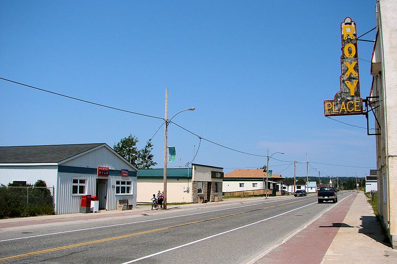
Nakina, harkening back to the old days of northern Ontario railway towns (Photo: User P199 at Wiki Commons.)

Nakina hit a boom in the 1970s when, in addition to its railway functions, the town was home to a large paper mill. This boosted the population to nearly double what it is today. Currently, however, minerals exploration and tourism are the largest industries today. Nakina is a starting point for many northern fly-in lodges. You can fly to lakes such as Makokibatan, part of the Albany River system. Fish for walleye, northern pike as well as brook trout.With both the pulp and railway industries definitely on the wane, it may be hard for Nakina to stem out-migration and beat the odds of being such a remote, northern town.

Train station in Nakina, Ontario Highway 11 Homepage

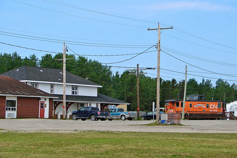
Nakina’s train station

Nakina advertizes along Highway 11 with its mascot, the “Nakina Mosquita”… I wish I had taken a photo of one of those signs. Thanks to Keith for sending in the photos of the rail station and of the end of Highway 584.

Aroland is an Oji-Cree First Nations town about 20 kilometres northwest of Nakina off Highway 584 on Highway 643. Approximately 300 people live in the community.

The surrounding area was a traditional camping ground in the late 18th and early 19th centuries due to good hunting, fishing and trapping. The Hudson Bay Company set up a trading post at nearby Kawpaskagami Lake in the early 1900s. The railway expanded to the area in 1911. According to the Chiefs of Ontario website, the Arrow Land and Logging Company, which operated in the area from 1933 to 1941, employed many Band members and contributed to the establishment of a permanent community.

The community is made up of members from many First Nations across the north, including former members from Long Lake, Fort Hope, Marten Falls, and Fort William Bands. The Aroland settlement is within the boundaries of the Robinson-Superior Treaty of 1850 and the James Bay Treaty of 1905 (known across the north as Treaty 9.)

Beardmore

Eighty kilometres west of Geraldton is Beardmore, the “Gateway to Lake Nipigon.”

Welcome to Beardmore, Ontario

Not a pride parade float, it’s the welcome to Beardmore sign!

Beardmore started out as a flag station on the CNR before finding itself in the middle of the Lake Nipigon gold ‘rush’ in the 1930s.  The town faced ‘rapid expansion’ after gold was found on the Sturgeon River, as evidenced by the Timmins-style hotels that unfortunately no longer serve as watering holes for the community.

Today, it’s a town of about 200 people focusing on forestry and serving as a take-off point for camping and boating near Lake Nipigon.  So it’s pretty small, and pretty quiet.  But what Beardmore lacks in amenities it makes up in uniqueness. I liked Beardmore.

Beardmore church

A church in Beardmore – completely unrelated to the text that appears above or below this photo

Beardmore is known for Vikings.

The Beardmore Relics, which were purported to be a cache of Viking artifacts, were found near the town in the early 1930s.

The relics – including an old sword, and axe, and a piece of a shield – were supposedly found while a prospector was panning for gold, and for a time were claimed as evidence that Vikings explored much further than Vinland, Markland, and Helluland while they were in North America, and that they explored parts of northern Ontario and maybe even Minnesota.

The Royal Ontario Museum purchased the relics and displayed them for about twenty years until they were forced to hold a public enquiry as to whether the relics were actually found in Beardmore, or imported by Scandinavian settlers desperate for a historic taste of home and passed off as a discovery in an elobarate hoax.

Beardmore, Ontario on Highway 11 Ontario highway11.ca

Highway 11 as it runs through Beardmore, Ontario.  Note the lounge-hotel at right, once a fixture of every town in northern Ontario.  (Photo: User P199 at Wiki Commons.)

In the “some big weird thing” sweepstakes Beardmore doesn’t disappoint.  Beardmore is also home to what it claims is the world’s largest snowman.  Does the title still count even though he’s not made of snow?  During the summer, the apparently nameless snowman sports sunglasses and fishing rod to signify that anything you can do, a snowman can do way cooler.

Beardmore, Highway 11's snowman capital, with the world's largest " snowman "

Neither rain, nor sleet, nor heat, nor hail will keep Beardmore’s snowman from standing watch over the community

The town sign isn’t just a normal wooden sign.  They’ve spelled out Beardmore on railroad ties in rainbow-coloured letters that you can’t miss. The town also has these nice new ‘Welcome to Beardmore’ pennants hanging from the lampposts.

This is what I love about Highway 11 communities.  They have pride. They have spunk. They have a sense of community. And this sense of community means that they’re not afraid to try.

Sometimes when you’re from a larger place you forget that, no matter where you’re from or where you live, everyone has some sense of pride in their hometown.  Beardmore is a place that reminds you of this.

Beardmore, Ontario war memorial - Highway 11Today Beardmore is a forestry and outfitting town, with a baseball field, a church, some gas stations and about 40 or 50 houses.  There is a Legion in town too.  Beardmore is the only real stop between Geraldton and Lake Nipigon, a 170 kilometre journey.

Beardmore is also where renowned artist Norval Morrisseau first showed his work to a Toronto exhibitor.

Sleeman

The Sleeman everyone knows and loves“One thing that will last a long time is the hockey, played under the Highway 11 concrete bridge that crosses the Sleeman Creek. If anyone should ever venture under there (winter would be best) they would find the names of many children through the years that play the great Canadian game under there, including mine.” — Richard, via email

No, it’s not the home of Honey Brown.  Sleeman Honey Brown is brewed in Guelph, not in Sleeman, Ontario.

Sleeman is is about ten kilometres east of Rainy River on the banks of the Rainy River. Sleeman is a hamlet of about 11 people located at the junction of highways 11 and 621. There’s a Lowes Lumber and a post office in town, but that’s it.

I am told that Sleeman started out along the river where a general store, post office and restaurant were a popular stop for the steamers and logging boats that jammed the Rainy River in the 1800s. Apparently much of the original store still stands – today, it is a residence at the end of Worthington Rd #5.

Sleeman was forced to shift gears from shipping to trains when the Canadian Northern Railway finished its bridge in Beaver Mills. As the trains sapped boat traffic, the town relocated to the railway about 1.5 miles north. The rail and new roads to the north and west brought much traffic and Sleeman grew to have a coffee shop and three general stores. Sleemaners know how to keep their heritage — two of them are still standing today. One is the current but renovated Lowes Lumber, while the other, located on First Street, is used as a storage shed since its closure around 1990. At one time, Sleeman had a church, a garage and car sales centre, a rail terminal, and like all northern Ontario towns, a local watering hole at the ‘luxury’ hotel. Sleeman peaked around 1950 and that’s when the decline started.View of the river from Sleeman, OntarioFormer resident Richard wrote of his fond memories growing up in Sleeman:

“As a boy I remember playing in the abandoned church, and when the natural gas line went through watching them demolish the brick store that happened to be in their way, or picking up the mail at the post office through the window that had also passed many groceries not so long before. One of my best friends lived at the site of the old garage and we often played around the ramps (there were no hoists then) or marveled at the old gas and oil signs. One of the best memories was Desi’s Drive in, a fast food restaurant that opened in the 60’s. Many nights were spent there with ice cream and many memories were built especially by my older siblings who probably have better memories than ice cream (lmao.) It closed in the early 80’s and a few years ago the garage that was out back burned to the ground taking with it the last remaining timbers of the old luxury hotel.

Thanks to Richard for the history on both Sleeman and Pinewood. Help add to this by emailing me at info (at) highway11 (dot) ca or by posting your thoughts below.

Rainy River

Rainy River is closer to Winnipeg than Thunder Bay – and considering it’s in the same province as places as far away as Windsor, Ottawa, and Welland, you can tell why some people in the north may feel a bit disaffected. I mean, technically, it is faster to drive from Toronto to Rainy River via the US, passing through Michigan, Wisconsin and Minnesota, rather than taking Highway 17 and/or Highway 11 the whole way.

Depending on the direction you’re travelling, Rainy River is either the start or the end of Highway 11.  Atwood Street in Rainy River is the terminus of Toronto’s Yonge Street – all 1600 kilometres of it.

Highway 11 Rainy River terminus end

Although this website sort of starts in Rainy River, If you came from the south, Rainy River is the end of Highway 11, meaning you have two options: you can take Highway 600 up through Lake of The Woods, or…

Rainy River International Bridge Higway 11

…or you can take the International Bridge across Rainy River to Minnesota (This photo and the above c/o Patrick.)

International Bridge in Rainy River

(Photo: Keith)

Rainy River is the gateway to northwestern Ontario – well, if you’re coming from the west, that is.  Rainy River is about 100 kilometres west of Fort Frances on Highway 11, and about 450 kilometres west of Thunder Bay.Rainy River began with a lumber mill in 1895 and by 1901 the CNR had a stop there.  By 1904 the town was established.  Today, its importance as a railway and logging town diminished, Rainy River is home to about 1000 people.  It’s an important border crossing, with access to Minnesota, and has plenty of outdoor activities.

Rainy River Locomotive, highway11.caRainy River is home to the 4008, a restored steam locomotive that used to run the CNR route to the town.  Much like the Shay in Iroquois Falls, the train is a testament to the old logging and railway industries which once dominated northern Ontario.  There is a railway heritage museum in town detailing Rainy River’s history with the railway.

Rainy River also has a marina, sports facilities, and both a buffalo and an elk farm.  There is a lot of hunting, fishing, boating, and swimming. Rainy River is one of the towns closest to the beautiful Lake of the Woods.

Rainy River hosts a few festivals including the mid-summer Railroad Daze, the Walleye Fishing Derby, and the Rainy River Giant Pumpkin Festival.  (Doesn’t some town in Nova Scotia have a giant pumpkin festival too? Where they row the carved pumpins like boats?  I don’t know.)

Post below, or email me at info (at) highway11 (dot) ca

Rainy River, Ontario, highway 11

Rainy River is small, but is a starting point for outfitting and anything to do with Lake of the Woods. (Photo: User P199 at Wiki Commons.)

Rainy River municipal building, highway11.ca

(Photo credit: User P199 at Wiki Commons.)